
For good or ill, New England’s rivers aren’t what they once were. Once the heart of the Industrial Revolution, rivers powered early industry and towns and cities were founded on their banks. This led to tremendous economic growth and prosperity, while at the same time changing the character of our rivers forever.
Most, if not all, rivers in New England have been dammed, diverted or de-watered for power generation and/or flood control. While this seems like a doom and gloom scenario (as it has been for some species, see: Atlantic Salmon) it presents a unique opportunity for whitewater boaters.
The best way to decide where and when to go boating starts with understanding how rivers function. Rivers are just one part of larger systems called watersheds. Watersheds provide the mechanism that transports water that arrived in the mountains in the form of rainfall or snow to the ocean. Watercourses higher up in the watershed will tend to be steeper and have less volume-these sections might be rated at a higher (more challenging) class while rivers downstream tend to be wider, flatter and hold more water. Knowing where your favorite run falls in within its watershed can give you a better sense of when it might run and at what level.
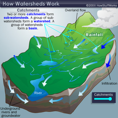
When a big rainstorm rolls through, you can often paddle the steep creeks toward the top of the watershed, and follow the water for the next few days as it advances through the system.
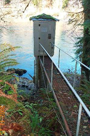
USGS Automated Guage
Thankfully, many popular whitewater runs are gauged, providing information on the timing of flows and the river level. This information is tremendously valuable and provides the consistency necessary to run rivers safely. There are two basic types of gauges; USGS gauges and ‘paddler’s gauges’. USGS gauges are automated stations that record timing and water levels. These transmit the collected information electronically to the USGS (United States Geologic Survey), which provides the information freely on the Internet. ‘Paddler’s gauges’ refer to anything that can provide a visual gauge of the river level.
USGS gauge information is tremendously valuable to whitewater boaters, however it is not tailored specifically toward kayakers. Because of this, it is often useful to get the information from another source. In the United States, the best resource for river information is American Whitewater [AW]. AW’s mission is “to conserve and restore America’s whitewater resources and to enhance opportunities to enjoy them safely.” This mandate has led to AW becoming a clearinghouse for river information including flow times and levels, advocacy issues and logistics information as well as information on river hazards. ![]()
Many popular whitewater sections are dammed, and therefore only able to be paddled when the dam releases. Dam operations are licensed by the Federal Energy Regulatory Commission, which requires recreational water releases on many rivers. An example of this is my home river, the Deerfield. Because of these scheduled releases, it’s easy for boaters to plan their vacations independent of rain showers-a great luxury. Dam operators often provide flow data, measured in cubic feet/second [CFS]. This flow information provides critical real-time flow data for boaters.
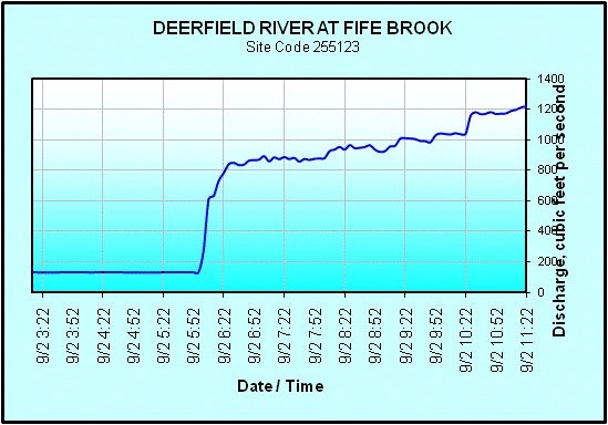
Fife Brook Section of the Deerfield flow graph, real time info.
Having flow data is more important than just a wasted trip to the river. Knowing when a river is at an optimal level provides a critical measure of safety. Whitewater features fundamentally change depending on water level, with each feature being different at different levels. As you might expect, higher flows often ramp up the intensity and challenge of a run.
The whitewater community is one based on information-what’s running, when and who’s going to be there. The flow of this information is critical to ensure that whitewater boaters have a great, and more importantly a safe time on the river.
One Response to Where’s the Whitewater? Understanding Whitewater Resources